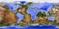
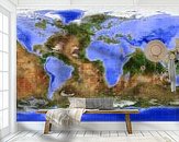
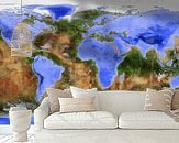
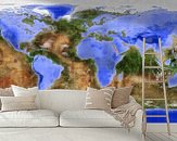
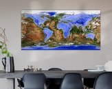
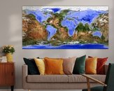
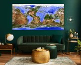
 Imagine all the land on Earth would be water and all the water would be land. Imagine the continents to be oceans and the oceans to be continents. Imagine all islands to be lakes and all the lakes to be islands. A complete inversion of topography. What would our world look like?
This inverted world map gives the answer: a planet with more than twice as much land surface as ours, grouped around a couple of huge water basins.
A large portion of all those lands will be sparsely populated or completely uninhabited. The continent Pacifica, surrounded by high mountain ranges, is one big desert. And the southern hemisphere below the 45th parallel is one globe-spanning Siberia.
But there are also lush green areas where life is good, such as the Mediterranean peninsula, the Big Islands in the Canadian ocean, and the region of the Indonesian lakes.
The color scheme of the map is inspired by the famous Blue Marble maps from NASA, which are based on the actual appearance of the Earth seen from space.
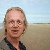
This artwork is offered by Frans Blok
My work can be located in the border regions of photography, painting and computer visuals. With my company 3Develop I do work in commission but I use the same techniques, skills and software to make free work. I am originally an architect and I live in Rotterdam; for that reason the architecture of that city is a major (but not the only) source of inspiration. But also travel to countries like Iceland and Britain, or walks in the Netherlands, provide much material. Seeing and showing quality and beauty, that is what my work is about.
Learn more about Frans Blok?
Customer reviews
This artwork doesn't have reviews yet.
3,731 customer rate us with a 4.7 / 5
 Germany
 Ordered in December 2019
Germany
Ordered in March 2024
Ordered in December 2019
Germany
Ordered in March 2024
 Netherlands
 Ordered in May 2021
Netherlands
Ordered in March 2019
Netherlands
Ordered in May 2021
Netherlands
Ordered in March 2019
Netherlands Ordered in January 2022
Netherlands
Ordered in November 2021
Germany
Ordered in September 2021
Germany
Ordered in October 2021
Germany
Ordered in November 2019
Netherlands
Ordered in February 2019
Germany
Ordered in July 2020
Netherlands
Ordered in November 2015
Ordered in January 2022
Netherlands
Ordered in November 2021
Germany
Ordered in September 2021
Germany
Ordered in October 2021
Germany
Ordered in November 2019
Netherlands
Ordered in February 2019
Germany
Ordered in July 2020
Netherlands
Ordered in November 2015
Pros and cons
- Thick photo paper
- Fine-art quality
- Frame the poster yourself
- Not mountable without a frame
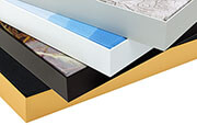
High quality art prints
Photoprints are printed on 260 grams heavy photo paper. Your favorite artworks are printed on the best printers with UV-protected inks. The print will not fade.
Learn more?
You will find more about Poster and the other materials at: